-
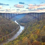
- The New River Gorge Bridge (Photo: Gary Hartley)
-

- Fayette Station Bridge (Photo: Danny Lee)
-
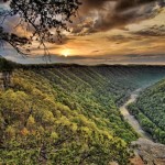
- Diamond Point Sunrise (Photo: Gary Hartley)
-
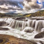
- Sandstone Falls (Photo: Gary Hartley)
National Park Service Maps
(Source: https://www.nps.gov/neri/planyourvisit/hiking.htm)Park Map - New River Gorge National River (570 kb Adobe Acrobat Document)
New River Gorge Scenic Drives (8.2 Mb Adobe Acrobat Document)
New River Gorge National River Trails Guide (16872 kb Adobe Acrobat Document)
Fayette Station Auto Tour (942 kb Adobe Acrobat Document)
Canyon Rim Area Trails (849kb Adobe Acrobat Document)
Thurmond Area Trails (1756kb Adobe Acrobat Document)Glade Creek Area Trails (862kb Adobe Acrobat Document)
Grandview Area Trails (400kb Adobe Acrobat Document)
Sandstone, Brooks Area Trails (748kb Adobe Acrobat Document)
Arrowhead Bike Trails Map (254 KB Adobe Acrobat Document)
Park Map - New River Gorge National River (570 kb Adobe Acrobat Document)
New River Gorge Scenic Drives (8.2 Mb Adobe Acrobat Document)
New River Gorge National River Trails Guide (16872 kb Adobe Acrobat Document)
Fayette Station Auto Tour (942 kb Adobe Acrobat Document)
Canyon Rim Area Trails (849kb Adobe Acrobat Document)
Thurmond Area Trails (1756kb Adobe Acrobat Document)Glade Creek Area Trails (862kb Adobe Acrobat Document)
Grandview Area Trails (400kb Adobe Acrobat Document)
Sandstone, Brooks Area Trails (748kb Adobe Acrobat Document)
Arrowhead Bike Trails Map (254 KB Adobe Acrobat Document)